Code Replicability in Computer Graphics

Code Replicability in Computer Graphics

Nicolas Bonneel, David Coeurjolly, Julie Digne. Université de Lyon, CNRS, France.
Nicolas Mellado. CNRS, IRIT, Université de Toulouse, France.

ACM Transactions on Graphics (Proceedings of SIGGRAPH 2020), 39:4


Being able to duplicate published research results is an important process of conducting research whether to build upon these findings or to compare with them. This process is called “replicability” when using the original authors’ artifacts (e.g., code), or “reproducibility” otherwise (e.g., re-implementing algorithms). Reproducibility and replicability of research results have gained a lot of interest recently with assessment studies being led in various fields, and they are often seen as a trigger for better result diffusion and trans- parency. In this work, we assess replicability in Computer Graphics, by evaluating whether the code is available and whether it works properly. As a proxy for this field we compiled, ran and analyzed 151 codes out of 374 papers from 2014, 2016 and 2018 SIGGRAPH conferences. This analysis shows a clear increase in the number of papers with available and opera- tional research codes with a dependency on the subfields, and indicates a correlation between code replicability and citation count. We further provide an interactive tool to explore our results and evaluation data.


We ran 151 codes provided by papers published at SIGGRAPH 2014, 2016 and 2018. We analyzed whether these codes could still be run as of 2020 to provide a replicability score, and performed statistical analysis on code sharing. Image credits: Umberto Salvagnin, _Bluenose Girl, Dimitry B., motiqua, Ernest McGray Jr., Yagiz Aksoy, Hillebrand Steve. 3D models by Martin Lubich and Wig42.

Bibtex

@article{replicability,
    author = "Bonneel, Nicolas and Coeurjolly, David and Digne, Julie and Mellado, Nicolas",
    title = "Code Replicability in Computer Graphics",
    journal = "{ACM} Transactions on Graphics (Proceedings of SIGGRAPH)",
    year = "2020",
    volume = "39",
    number = "4",
    month = "jul"
}
Persistence Analysis of Multi-scale Planar Structure Graph in Point Clouds

Persistence Analysis of Multi-scale Planar Structure Graph in Point Clouds

Thibault Lejemble (1), Claudio Mura (2), Loïc Barthe (1), Nicolas Mellado (1).
(1) CNRS, IRIT, Université de Toulouse, France.
(2) Department of Informatics, University of Zurich

Computer Graphics Forum (Eurographics 2020)


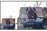
Modern acquisition techniques generate detailed point clouds that sample complex geometries. For instance, we are able to produce millimeter-scale acquisition of whole buildings. Processing and exploring geometrical information within such point clouds requires scalability, robustness to acquisition defects and the ability to model shapes at different scales. In this work, we propose a new representation that enriches point clouds with a multi-scale planar structure graph. We define the graph nodes as regions computed with planar segmentations at increasing scales and the graph edges connect regions that are similar across scales. Connected components of the graph define the planar structures present in the point cloud within a scale interval. For instance, with this information, any point is associated to one or several planar structures existing at different scales. We then use topological data analysis to filter the graph and provide the most prominent planar structures.

Our representation naturally encodes a large range of information. We show how to efficiently extract geometrical details (e.g. tiles of a roof), arrangements of simple shapes (e.g. steps and mean ramp of a staircase), and large-scale planar proxies (e.g. walls of a building) and present several interactive tools to visualize, select and reconstruct planar primitives directly from raw point clouds. The effectiveness of our approach is demonstrated by an extensive evaluation on a variety of input data, as well as by comparing against state-of-the-art techniques and by showing applications to polygonal mesh reconstruction.


Starting from an input point cloud equipped with normal vectors, our approach extracts meaningful planar components describing the geometry at multiple scales. Using persistence analysis, we offer to the user several ways to interactively explore, visualize and reconstruct the input data. The user can for instance generate planar reconstructions at arbitrary scales, select planar components by sketching directly on the point clouds, and/or find similar planar components.

Bibtex

@article{https://doi.org/10.1111/cgf.13910,
author = {Lejemble, T. and Mura, C. and Barthe, L. and Mellado, N.},
title = {Persistence Analysis of Multi-scale Planar Structure Graph in Point Clouds},
journal = {Computer Graphics Forum},
volume = {39},
number = {2},
pages = {35-50},
keywords = {CCS Concepts, • Computing methodologies → Point-based models; Shape analysis},
doi = {https://doi.org/10.1111/cgf.13910},
url = {https://onlinelibrary.wiley.com/doi/abs/10.1111/cgf.13910},
eprint = {https://onlinelibrary.wiley.com/doi/pdf/10.1111/cgf.13910},
year = {2020}
}
Proximity-Aware Multiple Meshes Decimation using Quadric Error Metric

Proximity-Aware Multiple Meshes Decimation using Quadric Error Metric

Anahid Ghazanfarpour, Nicolas Mellado, Chems-Eddine Himeur, Loïc Barthe, Jean-Pierre Jessel
CNRS, IRIT, Université de Toulouse, France.

Graphical Models, May 2020


Progressive mesh decimation by successive edge collapses is a standard tool in geometry processing. A key element of such algorithms is the error metric, which prioritizes the edge collapses to greedily minimize the simplification error. Most previous works focus on preserving local shape properties. However, meshes describing complex systems often require significant decimation for fast transmission and visualization on low-end terminals, and preserving the arrangement of objects is required to maintain the overall system readability for applications such as on-site repair, inspection, training, serious games, etc. We present a novel approach for the joint decimation of multiple triangular meshes. We combine local edge error (e.g. Quadric Error Metric) with a proximity-aware penalty function, which increases the error of edge collapses modifying the geometry in proximity areas. We propose an automatic detection of proximity areas and we demonstrate the performances of our approach on several models generated from CAD scenes.


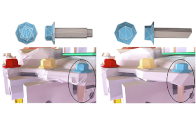
Left: Car scene with 425 meshes and 3M faces in total. Right: Result of our proximity-aware decimation to 150k faces in total. Some meshes are rendered with transparent material to better observe the scene complexity

Bibtex

@article{GHAZANFARPOUR2020101062,
title = {Proximity-aware multiple meshes decimation using quadric error metric},
journal = {Graphical Models},
volume = {109},
pages = {101062},
year = {2020},
issn = {1524-0703},
doi = {https://doi.org/10.1016/j.gmod.2020.101062},
url = {https://www.sciencedirect.com/science/article/pii/S1524070320300059},
author = {Anahid Ghazanfarpour and Nicolas Mellado and Chems E. Himeur and Loïc Barthe and Jean-Pierre Jessel},
keywords = {Mesh decimation, Quadric error metric, Geometry processing, Virtual disassembly},
}
SLAM-aided forest plots mapping combining terrestrial and mobile laser scanning

SLAM-aided forest plots mapping combining terrestrial and mobile laser scanning

Jie Shao (1,2), Wuming Zhang (3,4), Nicolas Mellado (2), Nan Wang (5), Shuangna Jin (1), Shangshu Cai(1), Lei Luo (6), Thibault Lejemble (2), Guangjian Yan (1).
(1) State Key Laboratory of Remote Sensing Science, Beijing Normal University, Beijing, China
(2) IRIT, CNRS, University of Toulouse, France
(3) School of Geospatial Engineering and Science, Sun Yat-Sen University, China
(4) Southern Marine Science and Engineering Guangdong Laboratory, China
(5) School of Remote Sensing and Information Engineering, Wuhan University, China

(6) Key Laboratory of Digital Earth Science, Chinese Academy of Sciences, China

ISPRS Journal of Photogrammetry and Remote Sensing, Vol. 163, May 2020


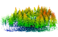
Precise structural information collected from plots is significant in the management of and decision-making regarding forest resources. Currently, laser scanning is widely used in forestry inventories to acquire three-dimensional (3D) structural information. There are three main data-acquisition modes in ground-based forest measurements: single-scan terrestrial laser scanning (TLS), multi-scan TLS and multi-single-scan TLS. Nevertheless, each of these modes causes specific difficulties for forest measurements. Due to occlusion effects, the single-scan TLS mode provides scans for only one side of the tree. The multi-scan TLS mode overcomes occlusion problems, however, at the cost of longer acquisition times, more human labor and more effort in data preprocessing. The multi-single-scan TLS mode decreases the workload and occlusion effects but lacks the complete 3D reconstruction of forests. These problems in TLS methods are largely avoided with mobile laser scanning (MLS); however, the geometrical peculiarity of forests (e.g., similarity between tree shapes, placements, and occlusion) complicates the motion estimation and reduces mapping accuracy.

Therefore, this paper proposes a novel method combining single-scan TLS and MLS for forest 3D data acquisition. We use single-scan TLS data as a reference, onto which we register MLS point clouds, so they fill in the omission of the single-scan TLS data. To register MLS point clouds on the reference, we extract virtual feature points that are sampling the centerlines of tree stems and propose a new optimization-based registration framework. In contrast to previous MLS-based studies, the proposed method sufficiently exploits the natural geometric characteristics of trees. We demonstrate the effectiveness, robustness, and accuracy of the proposed method on three datasets, from which we extract structural information. The experimental results show that the omission of tree stem data caused by one scan can be compensated for by the MLS data, and the time of the field measurement is much less than that of the multi-scan TLS mode. In addition, single-scan TLS data provide strong global constraints for MLS-based forest mapping, which allows low mapping errors to be achieved, e.g., less than 2.0 cm mean errors in both the horizontal and vertical directions.

Bibtex

@article{SHAO2020214,
title = {SLAM-aided forest plot mapping combining terrestrial and mobile laser scanning},
journal = {ISPRS Journal of Photogrammetry and Remote Sensing},
volume = {163},
pages = {214-230},
year = {2020},
issn = {0924-2716},
doi = {https://doi.org/10.1016/j.isprsjprs.2020.03.008},
url = {https://www.sciencedirect.com/science/article/pii/S0924271620300782},
author = {Jie Shao and Wuming Zhang and Nicolas Mellado and Nan Wang and Shuangna Jin and Shangshu Cai and Lei Luo and Thibault Lejemble and Guangjian Yan},
keywords = {Forest mapping, LiDAR, SLAM, Single-scan TLS, MLS},
}
Single Scanner BLS System for Forest Plot Mapping

Single Scanner BLS System for Forest Plot Mapping

Jie Shao (1), Wuming Zhang (2), Nicolas Mellado (3), Shuangna Jin (1), Lei Luo, Shangshu Cai (1), Lingbo Yang, Guangjian Yan (1),
(1) BNU – Beijing Normal University 
(2) ICJ – Institut Camille Jordan, 
(3) IRIT, CNRS, University of Toulouse, France

IEEE Transactions on Geoscience and Remote Sensing, Vol. 59, Feb. 2021


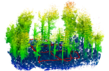
The 3D information collected from sample plots is significant for forest inventories. Terrestrial laser scanning (TLS) has been demonstrated to be an effective device in data acquisition of forest plots. Although TLS is able to achieve precise measurements, multiple scans are usually necessary to collect more detailed data, which generally requires more time in scan preparation and field data acquisition. In contrast, mobile laser scanning (MLS) is being increasingly utilized in mapping due to its mobility. However, the geometrical peculiarity of forests introduces challenges. In this article, a test backpack-based MLS system, i.e., backpack laser scanning (BLS), is designed for forest plot mapping without a global navigation satellite system/inertial measurement unit (GNSS-IMU) system. To achieve accurate matching, this article proposes to combine the line and point features for calculating transformation, in which the line feature is derived from trunk skeletons. Then, a scan-to-map matching strategy is proposed for correcting positional drift. Finally, this article evaluates the effectiveness and the mapping accuracy of the proposed method in forest sample plots. The experimental results indicate that the proposed method achieves accurate forest plot mapping using the BLS; meanwhile, compared to the existing methods, the proposed method utilizes the geometric attributes of the trees and reaches a lower mapping error, in which the mean errors and the root square mean errors for the horizontal/vertical direction in plots are less than 3 cm.


Bibtex

@article{9118969,
  author={Shao, Jie and Zhang, Wuming and Mellado, Nicolas and Jin, Shuangna and Cai, Shangshu and Luo, Lei and Yang, Lingbo and Yan, Guangjian and Zhou, Guoqing},
  journal={IEEE Transactions on Geoscience and Remote Sensing}, 
  title={Single Scanner BLS System for Forest Plot Mapping}, 
  year={2021},
  volume={59},
  number={2},
  pages={1675-1685},
  doi={10.1109/TGRS.2020.2999413}
}